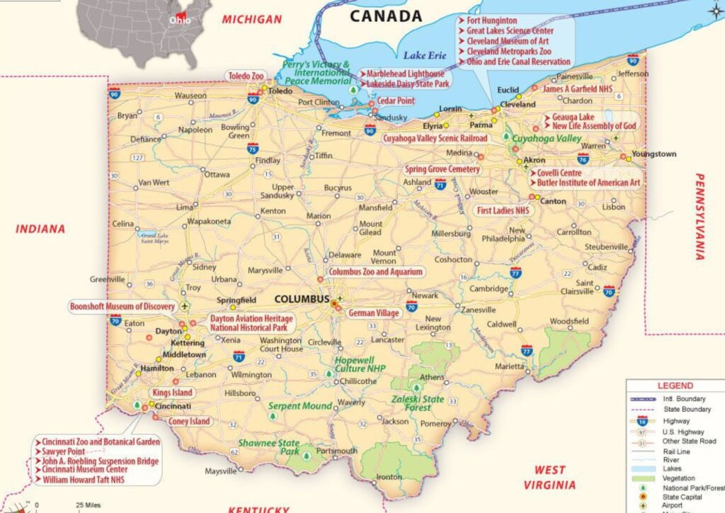
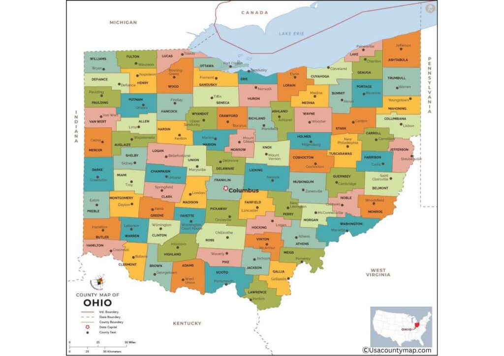
The Ohio County Map is a wide guide for the 88 counties that make up the state. Whether you are studying local government, planning road trips, or doing research on family history, a map of Ohio provides clear county lines and major city markers.

This helps you to see how Ohio’s counties are connected to the Ohio River. With a map of Ohio, you can easily detect the routes of Cleveland, Columbus, or Cincinnati. For students and residents, this map is a simple yet powerful tool for understanding the regional layout of Ohio.
Free Ohio County Map with Cities
A Free Ohio Map with cities is ideal for Ohio’s counties and major cities to find at a glance. This map clearly outlines county borders and cities such as Cleveland, Columbus, and Dayton. This is easy for business, education, or travel plans.

Teachers use a free Ohio map with cities to help students learn geography, while families use it to plan road trips across the state. For real estate and logistics, this map provides a quick reference to understand how the cities are spread over the counties. Downloading a free Ohio map with cities is practical for anyone in Ohio.
| City Name | County | Population | Area (sq mi) | ZIP Code(s) |
|---|---|---|---|---|
| Columbus | Franklin | 907,971 | 226.0 | 43004, 43201-43240 |
| Cleveland | Cuyahoga | 367,991 | 82.5 | 44101-44199 |
| Cincinnati | Hamilton | 309,513 | 79.5 | 45201-45299 |
| Toledo | Lucas | 268,508 | 80.7 | 43601-43699 |
| Akron | Summit | 189,347 | 62.4 | 44301-44399 |
| Dayton | Montgomery | 137,644 | 56.5 | 45401-45490 |
| Parma | Cuyahoga | 80,009 | 20.0 | 44129-44134 |
| Canton | Stark | 70,872 | 25.5 | 44701-44735 |
| Youngstown | Mahoning | 60,068 | 34.6 | 44501-44515 |
| Lorain | Lorain | 64,028 | 24.1 | 44052-44055 |
List of Ohio Counties
- Adams
- Allen
- Ashland
- Ashtabula
- Athens
- Auglaize
- Belmont
- Brown
- Butler
- Carroll
- Champaign
- Clark
- Clermont
- Clinton
- Columbiana
- Coshocton
- Crawford
- Cuyahoga
- Darke
- Defiance
- Delaware
- Erie
- Fairfield
- Fayette
- Franklin
- Fulton
- Gallia
- Geauga
- Greene
- Guernsey
- Hamilton
- Hancock
- Hardin
- Harrison
- Henry
- Highland
- Hocking
- Holmes
- Huron
- Jackson
- Jefferson
- Knox
- Lake
- Lawrence
- Licking
- Logan
- Lorain
- Lucas
- Madison
- Mahoning
- Marion
- Medina
- Meigs
- Mercer
- Miami
- Monroe
- Montgomery
- Morgan
- Morrow
- Muskingum
- Noble
- Ottawa
- Paulding
- Perry
- Pickaway
- Pike
- Portage
- Preble
- Putnam
- Richland
- Ross
- Sandusky
- Scioto
- Seneca
- Shelby
- Stark
- Summit
- Trumbull
- Tuscarawas
- Union
- Van Wert
- Vinton
- Warren
- Washington
- Wayne
- Williams
- Wood
- Wyandot
Ohio County Zip Code Map
An Ohio Zip Code Map combines county boundaries with postal zip codes, making it easier to manage mail delivery, business services, or targeted marketing. It is particularly useful for real estate agents, delivery drivers, and businesses requiring accurate regional breakdowns.

By using the Ohio Zip Code Map, you can detect specific zip codes within each county, making it simple to plan sales routes or service areas. This map helps residents understand which zip codes belong to their communities. Whether you are organizing bulk mail or analyzing demographics, an Ohio Zip Code Map is a practical tool.
Ohio County Map with Roads
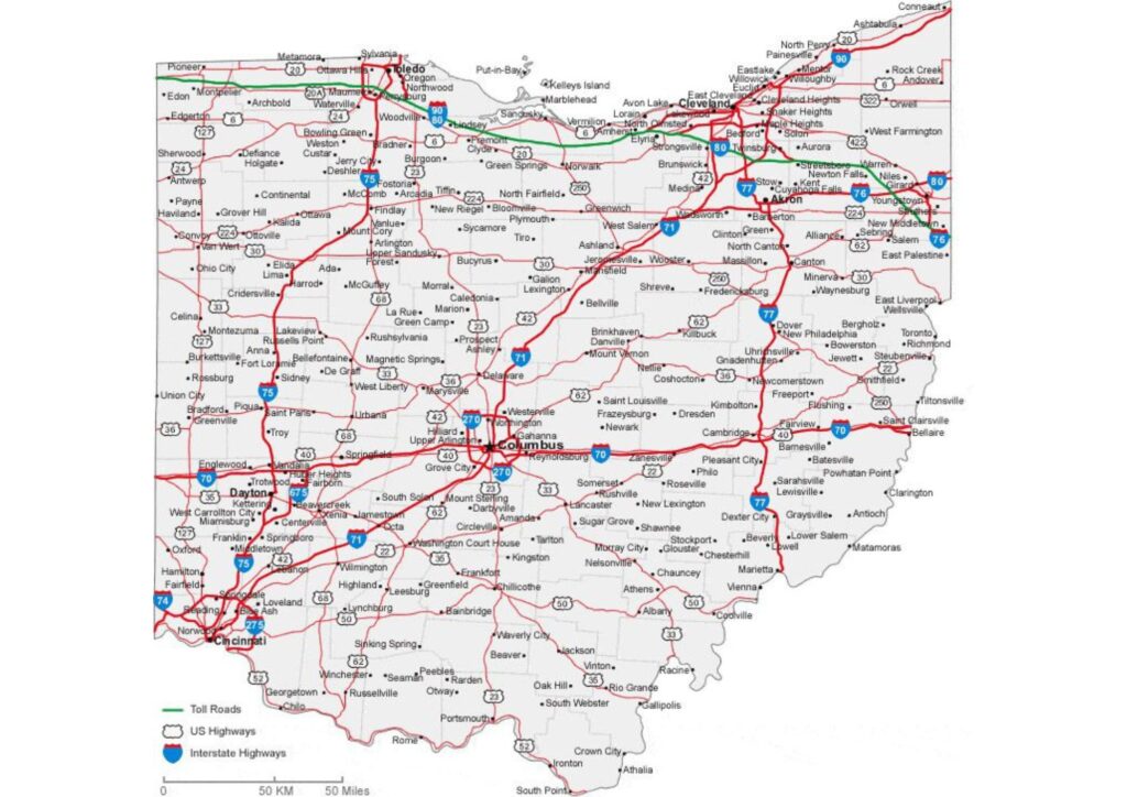
The Map of Ohio with roads is an important companion to navigate Ohio’s highways, interstates, and local roads. This shows county lines with all major routes, helping passengers to plan skilled trips. For businesses, trucks, and emergency services, the map of Ohio with roads provides clarity on the best routes across the state.

Tourists can use it to find beautiful drives through a straight route for rural areas or cities in Ohio. It is also very good for road construction schemes and regional development. Place a map of Ohio with roads in your vehicle for safe, more informed travel in Baki state.
